- +255 756 346 878
- info@awarenessafricasafaris.com


Our Tanzania itineraries are very unique and each one is different. Rather than simply asking you to choose, we customize your trip to suit your individual needs.
Our Tanzania itineraries are very unique and each one is different. Rather than simply asking you to choose, we customize your trip to suit your individual needs.
Our Best Outdoors
#1 Beach Holiday
Our Tanzania itineraries are very unique and each one is different. Rather than simply asking you to choose, we customize your trip to suit your individual needs.
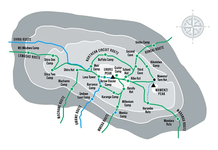
This is 7 days itinerary of the Rongai route with an additional day for acclimatization. Gradually descending towards Uhuru Peak, the Rongai route starts from the north side of Kilimanjaro. We recommend this route to climbers who have no previous experience climbing at higher altitudes, and to those who are just starting to climb with little or no mountaineering experience.
In terms of difficulty, the Rongai route can be rated as moderate because it is not as demanding as other difficult routes
because it has a gentle slope and an equally gentle approach to the summit.
The Rongai Route may offer an almost level slope but its main disadvantage is that climbers are more likely to suffer from altitude sickness (AMS) because it does not follow the “climb high, sleep low” rule strictly that Is needed for acclimatization. In order to combat the high altitude sickness problem, we recommend that you add an extra day for acclimatization when plying this route
Drive to the attractive wooden village of Nalemoru (about 4 hours including a stop to get permits at Marangu). Your expedition would be started only when; your porters get prepared. At the beginning, you would hike through wide path that wind through fields of maize and potatoes before entering pine forest where you can encounter a considerable numbers of wild species. You would have your first camp at the end of the moorland zone where the forest gets thin. The exotic views of the Kenyan plains from here would enthrall you. Elevation: 2000m to 2650m, Distance: 6km, Hiking Time: 3-4 hours, Habitat: Montane Forest,
Elevation: 2650m to 3450m, Distance: 6km, Walking Time: 3-4 hours, Habitat: Moorland The morning hike is a steady ascent up to the Second Cave with superb views of Kibo and the eastern ice fields on the crater rim.
Elevation: 3450m to 3600m, Distance: 9km, Walking Time: 2-3 hours, Habitat: Semi-desert, Head out across the moorland on a smaller path towards the jagged peaks of Mawenzi. The campsite is in a sheltered valley with giant Senecios nearby.
Elevation: 3600m to 4330m, Distance: 6km, Walking Time: 3-4 hours, Habitat: Semi-desert A short but steep climb up grassy slopes is rewarded by superb views. Leave the vegetation behind shortly before reaching the next camp at Mawenzi Turn, spectacularly situated in a cirque directly beneath the towering spires of Mawenzi. The afternoon will be free to rest or explore the surrounding area as an aid to acclimatization. If you are spending an extra day on the mountain, you will camp for two nights here. You can hike up and around Mawenzi for your acclimatization hike.
Elevation: 4330m to 4750m, Distance: 9km, Hiking Time: 4-5 hours, Habitat: Alpine Desert Cross the lunar desert of the ‘Saddle’ between Mawenzi and Kibo to reach Kibo campsite at the bottom of the Kibo crater wall. The remainder of the day is spent resting in preparation for the final ascent very early.
Elevation: 4700m to 5895m & down to 3700m, Distance: 6km up & 15km down, Hiking Time: 6-8 hours’ up & 15km down, Habitat: Alpine Desert Very early in the morning (midnight about 2am), commence the climb to the summit on steep and heavy scree or snow up to Gilman’s Point located on the crater rim (elevation 5700m). Continuing ascend to Uhuru Peak, which is the highest point in Africa. There are unbelievable views at every turn. Have your picture taken at the summit to show your friends and family. Start descending and take a stop at Kibo for lunch before exploring the Horombo encampment. The day of summit is the most difficult day of hiking as you have to start earlier to reach on the top to see the sun rise, so take the bare necessities like the headlamp/ flashlight, the warm clothes and the camera with you. Remember you have to trek in the night and reach on the top short after or before the sunrise to see the best of the Kilimanjaro beauty. Make sure, you may be tired, so it is always recommended to go slow to the summit.
Elevation: 3700m to 1700m, Distance: 20km, Hiking Time: 4-5 hours, Habitat: Forest After breakfast, a steady descent takes us down through moorland to the Mandara Hut.From there you would have to descend through lush forest path to attend our destination: the National Park gate at Marangu. Remember the lower elevations can be wet and muddy, so descend slowly and don’t wear long dress: The Shorts and t-shirts will be very comfortable at the time. A vehicle will meet you at Marangu gate to drive you back to your Hotel in Moshi (about 1 hour).
Yes ! This tour is suitable for everyone. You can book this tour as a solo traveler or as a couple. We also offer this tour for small and large groups who are willing to travel together. Do not hesitate to contact us and our specialist will be happy to help you plan your vacation in Africa.
Do not hesitate to call us. We are a team of experts and look forward to speaking with you.


+255615993878
+255 756 346 878
info@awarenessafricasafaris.com
Moshi - Tanzania

